Located In: Shamrock, TX

Property Description

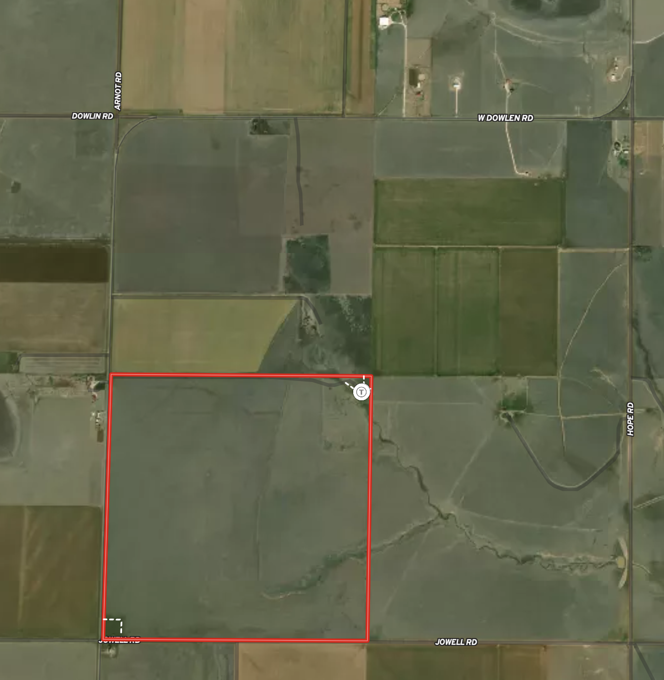
Situated in the southwest quadrant of Wheeler County, Bar T Ranch is a hunter’s paradise. Only 2 miles off of the North Fork of the Red River, this section also has the Sand Creek meandering through the middle of the property. Along with two sizable spring-fed fishing ponds stocked with big bass and blue gill along the creek. There is good brush cover conducive to wildlife, including whitetail deer, quail, turkey and dove. Notable quail, turkey and whitetail deer hunting on this property. There is great access, yet retains a sense of seclusion giving Bar T Ranch the best of both worlds. The property is fenced entirely around the perimeter for cattle and fencing is considered to be in good condition with new fence along the western boundary. Deer blinds and feeders are strategically placed throughout the property. There is one windmill on the southern boundary of the property with an overflow tank, and also electricity is located just outside the property near the southwest corner. The grass has been well managed and in good condition for cattle. This is an awesome little honey hole recreational spot, don’t miss it!

Price: $1,376,000

Status: Sold

Type: Land

Size: ±640 Acres

Want Updates?

Be the first to know!

TEXT LAND51 to 806-452-4090

Bar T Ranch is located northwest of Shamrock in Wheeler County.

Property Info and Links

Location:
Bar T Ranch is located 5 miles north of I-40 and the community of Lela, and approximately 10 miles northwest of Shamrock and 18 miles northeast of McLean. Amarillo International Airport is an hour drive to the west, and approximately 160 miles from Oklahoma City, OK.
 
Water:
There is one windmill and overflow pond, located on the southern perimeter of the property. A seasonal creek, the Sand Creek, runs through the middle of the section, along with spring fed stocked ponds along the creek, providing additional water for livestock and wildlife. The property is situated about 2 miles off of the North Fork of the Red River.
 
Hunting:
The area is known for an abundance of sizable whitetail deer, quail and turkey. The property is also conducive for dove, some water fowl and ideal for fishing.
 
History:
The property has primarily been used for grazing cattle, fishing and hunting.
 
Improvements:
The property features new 5-strand barbed wire along the western boundary, and the other boundary fencing is considered to be in good condition. There is one windmill with an overflow pond along the southern boundary that is one source of livestock water. The property has also been enhanced with two spring-fed, stocked ponds along the seasonal creek. The property also includes 3 deer feeders, 3 blinds, 3 fish feeders and several quail feeders throughout the property. Electricity is ran just outside of the southwest corner of the property, at the intersection of CR 10 and CR V.
 
Minerals:
It is unknown the current percentage of owned mineral rights. The seller will convey all mineral, wind, water and solar rights with acceptable offer.
 
Landscape:
The property is rolling terrain with around 100 foot elevation changes across the section, with the creek bottoms accounting for the lower elevations. The soils here within are listed with accompanying percentages for area of interest totaling 100%: Devol loamy sand (DID) 39.71%, Obaro-Quinlan association (OuD) 21.49%, Hardeman fine sandy loam (HaD) 8.88%, Lincoln soils (Ln) 8.19%, Lutie silt loam (LuC) 7.81%, Tivoli fine sand (Tv) 6.43%, Grandfield fine sandy loam (GfC2) 5.47% Devol loamy sand (DIB) 0.71%, Grandfield fine sandy loam (GfB) 0.68%, Grandfield fine sandy loam (GfC) 0.52% and Lutie silt loam (LuB) 0.10%.
 
Please see Soil Report for more details.
 
Exclusions:
There are no known exclusions at this time.
 
Zoning/Easements: 
The property is outside of any municipality so is not zoned. There are no known easements that would affect operation of the land. It is anticipated all existing easements will be identified by the title search and/or surveyors.
 
Estimated Taxes:
*$621.99
*This is an estimated taxes for 2022. Potential buyers will be responsible for verifying the taxes with any potential exemptions.
 
Water Conservation District: 
Bar T lies within the Panhandle Groundwater Conservation District. Check their website for more information.
 
Area:  
The property is located in the southwestern quadrant of Wheeler County and sits north of Interstate 40 and west of Highway 83, just west of the North Fork of the Red River.
 
Access:
The property is accessible from dirt county roads. The property can be accessed by County Road V, County Road 10, or County Road 11. There are multiple entrances to the property.
 
Directions:
From Amarillo: 79 miles east on I-40 to County Road 11 (about 13 miles east of McLean). Go North on CR 11 for 5 miles to southeast corner of the section and where gate to property is located.

Contact Us

Triangle Realty is here to support you. Please complete the form below, and we will be in touch with you shortly.

Don’t want to fill out a form? Give us a call anytime at 806.367.8334, or email here to get in touch directly.

  • This field is for validation purposes and should be left unchanged.

1
Good Condition Perimeter Fencing

2
±640 Acres

3
Multiple Feeders and Hunting Blinds

4
2 Stocked Spring Fed Ponds

Property Map

Sold Listing Agent: JT Haynes | Broker/Owner

Licensed In States: TX, NM, OK, & CO

E-mail: jtj@trianglerealtyllc.com | Cell Phone: 806-513-5055

Meet JT Haynes